The Annapurna Circuit is a legendary trek in Nepal that has been a popular destination for travelers since the region was first opened to foreigners in 1977. As its name suggests, it circumnavigates much of the Annapurna range in the Himalaya, depending on where you start and stop your trek. The Annapurna Circuit is often said to be one of the best long distance treks in the world because of the wide variety of climates and cultures that are experienced along the way. The terrain varies from agricultural fields to dense jungle to high alpine Tibetan plateaus, elevations on the trek range from 800 m to 5400 m, and until recently, many of the villages in the region had very little exposure to modern influences.


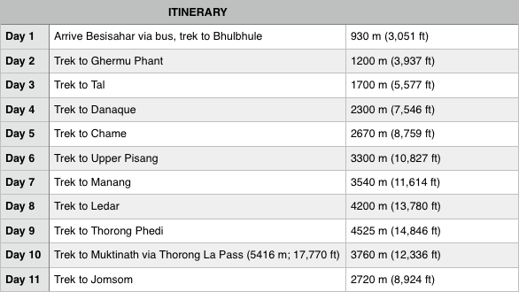
Having just completed the Three Passes Trek in the Solukhumbu region of Nepal, we were absolutely loving our time in the Himalaya, so we thought we’d see what the Annapurna Circuit hype was all about. We decided to do what is now a popular version of the trek, beginning in Besisahar (reached from Pokhara or Kathmandu via a 4 or 7 hour bus ride) and ending in Jomsom. Included in this post, you’ll find our itinerary, packing list, and other information about our trek.
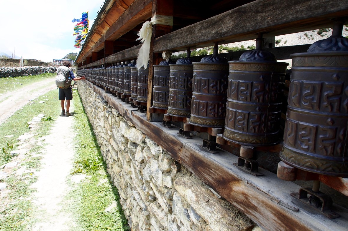
Prayer wheels outside of Manang

Wild section of trail en route to Tal
First, it is important to note that we were trekking from May 25th to June 4th, which is considered less than ideal by most because June marks the beginning of the monsoon season in Nepal. October is the most popular month for trekking in the Himalaya, followed by April, because these months tend to have the best weather. Thus, if you plan on trekking during the busier months, your experience may be quite different than ours.


In particular, we heard that during April and October, the Annapurna Circuit is often so crowded that the teahouses fill up early and it can be hard to find lodging. This was far from a problem for us. Several nights, we had teahouses all to ourselves, and the villages were typically quiet. Despite it being monsoon season, we only experienced rain twice, although clouds often obscured views of the higher peaks.


The four hour bus ride from Pokhara to Besisahar was a bit rough and crowded, but tolerable for $5/person. Many people begin their trek in Besisahar as we did, but it’s no longer the end of the road, so you have the option to pay for a jeep to take you further (more on “the road” later). In our opinion, the only good reason to do this would be a) if you are short on time or b) if you want to escape the lower elevation heat. It was miserably hot when we arrived at 11:30 am in Besisahar, but we were pleasantly surprised by how much we enjoyed the scenery at the lower elevations, and it was fascinating to see our surroundings change as we climbed higher. 


The trek begins in an agricultural region where villagers can be seen employing old world farming methods. As the trail winds up scenic river valleys, the terrain transforms into dense jungle. Lush greenery covers the impressively steep valley walls and there are raging waterfalls around every corner. There are plenty of birds, bugs, and colorful flowers, and we even saw monkeys near the village of Danaque.


Slowly, pine trees appeared and the terrain began to feel more like the mountains we are used to. As you reach the alpine villages, the higher peaks become visible and the terrain changes once again. Here, we saw the famed blue sheep from Peter Matthiessen’s Snow Leopard, and a wake of massive griffon vultures taking down an animal carcass.


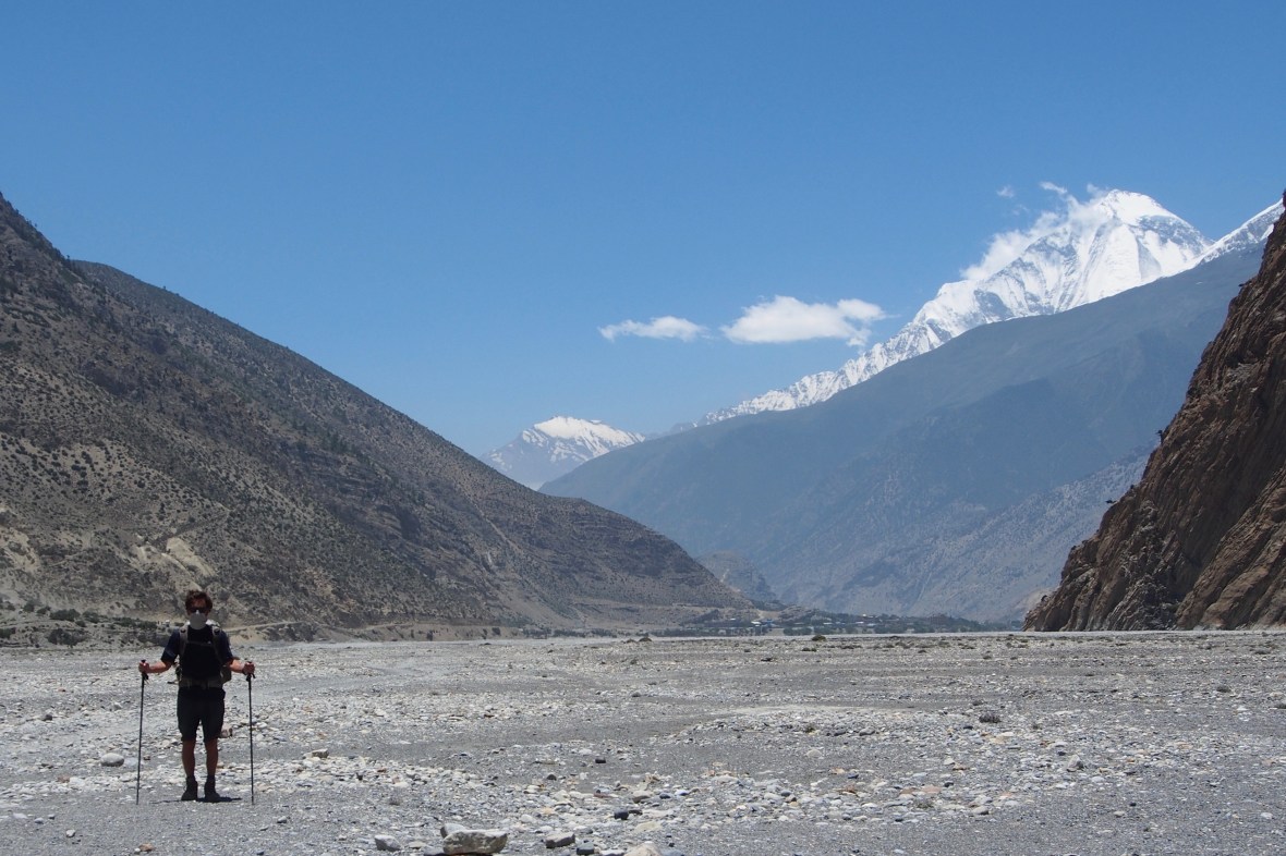
The trek culminates with the crossing of Thorung La pass, considered to be the world’s highest trekking pass at 5,416 m (17,770 ft). Proper acclimatization is essential given the elevation of the pass. Most trekkers accomplish this by spending two nights in Manang, one of the larger villages that sits at 3,540 m, and then by trekking to Tilicho Lake, which is the “worlds highest lake” (for its size – there are actually many higher lakes) at 4,920 m. We were already somewhat acclimatized, having just spent nearly three weeks above 4,000 m on our last trek in the Solukhumbu, and because we were on a tighter schedule, we bypassed Tilicho lake. However, the importance of proper acclimatization cannot be emphasized enough. Don’t rush over the pass until you’re ready, and be knowledgable about how to recognize and manage symptoms of altitude sickness.
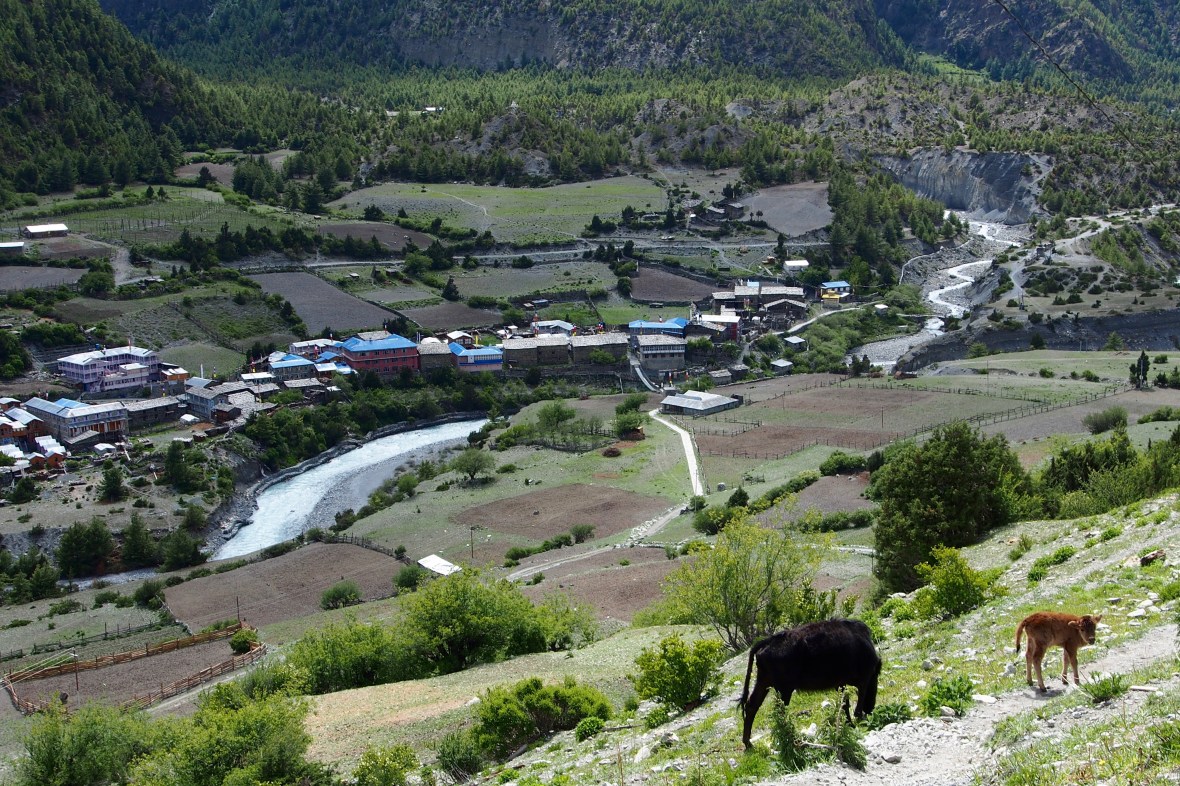
View of Lower Pisang from our lodge in Upper Pisang
We spent the night in Thorong Phedi (4,525 m) before crossing the pass. Some opt to go a bit higher to “High Camp” (4,925 m) before crossing the pass; however, we thought we’d sleep better at a slightly lower elevation. Generally, it is recommended to sleep no more than 300 – 500 meters higher than you did the previous night, so we found it surprising that the local guides often take people straight from Ledar to High Camp, a gain of 700 meters. A bonus of staying in Thorong Phedi is that the lodging/food is cheaper because there’s only one hotel at High Camp.


We were happy with our decision to stay the night in Thorung Phedi since the hill up to High Camp took us only 40 minutes the next morning. In an additional two hours, we reached the pass, though our performance was likely aided by acclimatization from our previous trek (many trekkers took much more time to ascend). We were advised to reach the pass before 9am because the chances of poor weather and high winds increase significantly in the late morning and afternoon. We left Thorung Phedi at 5am, reached the pass around 8am, and lucked out with some truly spectacular weather.
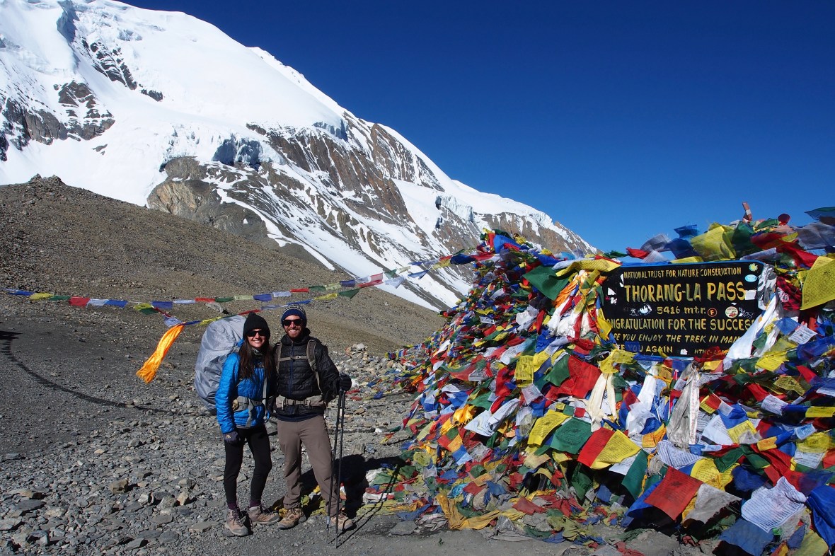
Success! The crossing of Thorong La (5,416 m; 17,770 ft) was by far our favorite part of the trek.
After crossing the pass, you descend a knee-busting 1,656 m (5,433 ft) to reach the village of Muktinath, where you are instantly transported into yet another a new culture and what feels like another era. This is the lower Mustang region, where Tibetan culture is prominent, and the terrain has the look and feel of high alpine Tibetan desert. There are sacred Hindu and Buddhist temples in Muktinath, making it a popular destination for followers of both faiths. Horses decorated with colorful ribbons carry those making their pilgrimage to the temples up and down the streets of the village all day long. Not knowing much about this region prior to our arrival, we found Muktinath to be a pleasant surprise, both fascinating and charming.


Lubra pass, in between Muktinath and Jomsom, offers great views of Dhaulagiri (8,167 m; 26,795 ft) but is definitely a challenging ascent and descent to take on the day after doing Thorong La
Although strong winds, hot temperatures, jeep traffic, and a lot of dust made the final stretch of the trek to Jomsom pretty brutal, the crossing of Thorong La and our time in Muktinath really cemented our feelings about the trek. The primary purpose of trekking the Annapurna Circuit is not to see the spectacular Annapurna Himal. Rather, the primary draw is to experience diverse cultures and the wide variety of terrain and wildlife as you travel through this unique region.
The hot, dusty, windy trek to Jomsom
After deciding to wrap up our trek in Jomsom, we took a bus back to Pokhara that took close to 10 hours for $10/person. The ride was long and came to a frustrating end when the driver refused to drop us off in the tourist district of Pokhara, requiring us to pay for an additional taxi. If your budget allows, you might be better off taking a jeep ($17/person) or a flight ($100/person).

Locals capitalize on hot and hungry tourists when landslides block the roadways. We were stopped in the heat for three hours waiting for a slide to be cleared on our way to Pokhara, so we caved and got some ice cream.
The road: As you may have heard, there is now a road for most of the Annapurna Circuit route. Many trekkers are turned off by this, as were we. However, it is probably far from the road you are imagining – it’s no busy concrete highway. It’s a primitive dirt road, wide enough only for a single vehicle. In the monsoon season, it is often damaged by landslides and can be out of service for days at a time. There are parts of the trek where you must use the road, but there are also many sections where the trail separates from the road and you may even forget it is there. During our trek, the road was fairly quiet from Besisahar to Manang, and we were rarely passed by cars or motorbikes (although there is likely more traffic during the high season). The Muktinath to Jomsom side of the road was far busier.

In spite of all the complaints about the road, the Annapurna Circuit remains one of the most popular treks in the world.
Pokhara is the launching point for Annapurna treks and makes for a great place to chill for a few days after your trip. Situated on scenic Phewa Lake, it is a refuge for trekkers and travelers. It has a laid back, hippie vibe, especially compared to the hectic streets of Kathmandu, and there are plenty of lakeside bars and restaurants as well as affordable spas, meditation and yogic healing centers, and the like. We stayed at a few hotels in town and preferred Hotel Ezen, which was clean and updated, and it was a great value at $15/night (with A/C!).


Paragliders sailing down to Phewa Lake
Activities abound in Pokhara: you can paddle around the lake in a kayak or rowboat ($5), or paraglide ($120) from the nearby Sarangkot hillside (~30 min jeep ride). The International Mountain Museum ($4) and World Peace Pagoda (donation) are also nearby and worth a visit. You can catch a cab for $2 – $5 around the city or as we did, rent a motorbike ($8-$12 /day) to get around.


There are a lot of restaurant options including excellent Nepali and Western food. We’d recommend Pokhara Thakali Kitchen for local Nepali cuisine. If you’re craving pizza, Roadhouse Cafe had some of the best we’ve ever had, in addition to surprisingly decent wine. Himalayan Java was our favorite place for fresh espresso, breakfast/lunch/smoothies, and relaxing while using wifi. From Pokhara, you can bus (between $5-$15 USD) or fly (~$100) back to Kathmandu.
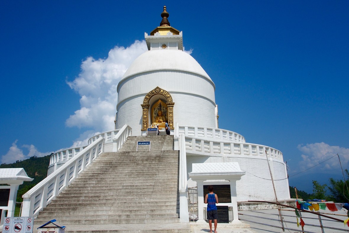
Pokhara Peace Pagoda
Overall, while the Annapurna Circuit may be past its prime, in our opinion it is still a worthwhile trek through a scenic and fascinating region that is undergoing a lot of development.

“Hole in the Wall” – funky little bar in Kathmandu
Annapurna Circuit Packing List
Here is a list of everything we brought on the trek (some gear from home, most we bought in Kathmandu), and few things we wish we would have brought (per person):
- Trekker Information Management Systems (TIMS) permit and Annapurna Conservation Area Permit (ACAP): can be acquired in Kathmandu or Pokhara (each permit is ~$20 USD per person)
- Down sleeping bags: -10 for her, -5 for him (plenty warm – teahouses provided extra blankets as well when needed)
- Cocoon sleeping bag liner (1)
- Down jacket (1)
- Gortex rain shell jacket (1)
- Waterproof backpack cover (1)
- Beanie (1)
- Buff/bandana (2) – keep dust out of your mouth, sun off your neck, and more
- Scarf
- Lightweight hiking pants (1) – you do not need soft shell or heavy hiking pants
- Shorts (at least one pair for trekking at lower elevations – a pair of convertible pants would suffice, maybe a second pair of shorts for sleeping at lower elevations)
- Warm, comfy pants to wear in teahouses and for sleeping (1)
- Short sleeve hiking t-shirt (2)
- Long sleeve hiking shirt (1)
- Base layer bottoms for layering warmth (1)
- Base layer top for layering warmth (1)
- Warm long sleeve top for teahouses/sleeping (1)
- ~5 pair socks
- ~2-5 pair underwear
- Sunglasses
- Hiking boots
- Sandals
- Shampoo, lotion, chapstick, toothpaste/brush, toilet paper, hand sanitizer, soap, baby powder, baby wipes (50 each – we use 2-3 after a long day of hiking for a quick rinse)
- Sunscreen
- 4 lbs food – Snickers, peanuts, chocolates, hydration salts
- Water bottle – 1 liter Nalgene or stainless steel (stainless steel is nice since it can be used to heat on the teahouse stoves for warm water)
- Travel towel
- Trekking poles
- Emergency kit: ibuprofen and opiate painkillers, diamox, cortisone cream, antibiotic ointment, prescription antibiotics, antiparasitics, bandages/medical tape, water treatment tablets, DayQuil/NyQuil or other cough/cold medicine, treatment for any other conditions to which you may be prone (do not count on being able to find anything at the pharmacies in Nepal)
- Duct tape and zip ties for repairs
- MSR Autoflow Gravity water filter
- Small 15 L daypack for day hiking (probably unnecessary but nice to have)
- Map
- Headlamp with charger and/or extra batteries
- Deck of cards (most days you’re done hiking before noon – lots of down time)
- Earplugs
- iPhone and charger
- Small combination lock, helpful for teahouse rooms so you won’t have to keep track of room keys
- Journal & pen
- Olympus OM-D E-M5 Camera with extra battery, extra memory card, and battery charger
- Kindle with charger

Boudhanath stupa in Kathmandu is the biggest stupa in Nepal and well worth a visit

Rooftop drinks at Bar Bar Black Sip in Kathmandu with the bar’s delightful owner – highly recommended!
If you have questions about our trek or our time in Nepal, please comment on the blog or send us a message on Instagram @theadventuregoeson! We’d love to share more of our experience with you. You may also want to check out our post about the Three Passes Trek in Nepal, which includes a video summary and other helpful tips for trekking in Nepal.
Namaste!


Living the dream! Amazing pictures and exquisite writing… again! ❤️❤️❤️
Thanks Mama!! Love you!
WOW This is better than getting the National Geographic! Love ya Sue B.
Thanks Sue! Miss and love you!!
We got our Nepal post card this week. Thank you! They ran in to the house to have me read it to them. In our Nepal reading we read about yaks and Sherpa’s and having to carry everything and the next day I heard them ‘porting’ their things up and down the stair to the loft. We also had a book about how kids get library books around the world. They are curious if you saw any library elephants, camels, or bikes during your travels? You had been to several of the countries mentioned in the book and they were so excited to recognize the names of the countries.
That is so sweet, I love it! You can tell them that so far we’ve seen one camel (in Vietnam – pretty sure it didn’t belong there), a few elephants in China, and lot’s of libraries and bikes. So glad they are enjoying following along with our journey! Sending lots of love your way! 🙂 xo
Hi, all of your travels look amazing! The pictures from the Nepal trip are stunning. I’m thinking of trekking in Nepal later this year and have long considered EBC, but friends and blogs have noted, like you did, how crowded it can be. Choosing which trek to do instead is exciting but a little overwhelming! Can you shed some light on how you made your choice for Annapurna Circuit and Three Passes (you touched on this re: Three Passes)? Mustang has been recommended and/or Gokyo Ri might be calling my name.
Hi Angela! For us, the Everest area was our main priority, not necessarily base camp, but all of the mountains in the region. They’re the epicenter of the mountaineering world, and we’re fans, so we have a bias toward Everest. We chose the three passes as the best option to see as much of the area as possible, and as you’ve read, it’s easy to see base camp as part of this trek.
Annapurna has one of the best histories, known around the world as an amazing and varied trek through diverse cultures and terrain. It was all of those things, but it wasn’t half as cool as three passes. The end of Annapurna Circuit is in the Mustang valley, so we got glimpses of what that would entail: picture Tibet, much drier, more barren and brown than most of Nepal, but also untouched, less people and better preserved culture. Gokyo Ri is part of the three passes and is amazing. We spent 4 days in Gokyo because it’s a beautiful, laid back town on a picture perfect lake. You really can’t go wrong, and each trek depends on your preferred style.