If you haven’t yet read our overview post about the 14 day Walker’s Haute Route, you may want to check that one out first. This post is more detailed, part 1 of 2 with daily details from the two week hike.
Day Zero: We spent three days in beautiful Chamonix lounging, exploring, and prepping for the trek. We stayed at Les Arolles, an affordable campground within walking distance of town (17 Euro/night for 2 people and a tent), and we spent one night at Auberge de Jeunesse Hi Chamonix because they offered to store some things for us during our trek for just 1 Euro (best deal we could find). We even snuck in a fabulous trail run to nearby Mer de Glace, where we also found incredible views of Les Drus (3,754m), Les Grands Jorasses (4,205m) and the Aiguille du Grepon (3,482m). And then we were off!
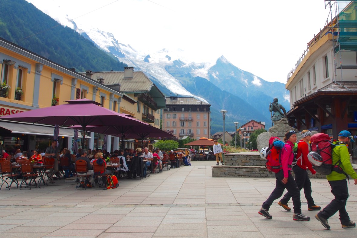
Ropes, crampons, and ice axes are standard fashion accessories in downtown Chamonix
Day One – Chamonix to Argentiere (9km, 214m elevation gain): When setting off on a 14 day hike, does the weather forecast even matter? We decided no. With that in mind, we walked out of rainy Chamonix on the afternoon of July 24th with heavy packs and wet everything. After a few hours of walking up muddy trails, we reached Argentiere, where we set up the tent in the rain, crushed a good camp stove dinner, and laid down. Both of us were thinking about how hard this trek was going to be if the weather didn’t change, but neither of us were willing to say it out loud. Did four dry years in California burn off our tough, rain resilient Seattle exteriors?


Day Two – Argentiere to Le Peuty (12km, 953m gain, 925m loss): The weather didn’t change overnight, so we got the day started in the tent, preparing coffee and breakfast in the vestibule without leaving our sleeping bags. Then, we packed up the sloppy mess and headed out for our first full day on the trail. We wound up the twisting route through the woods, thankful for the big evergreens that shielded some of the rain. After an hour and a half, we reached the small town of Le Tour and for the first time on this trip (and not the last), we looked up a steep ski slope to see tourists, climbers, and bikers riding the ski lifts up the mountainside. We stubbornly decided right there that we wouldn’t take a lift, a bus, a tram, a helicopter, or any other means of transport other than our feet until we reached Zermatt.
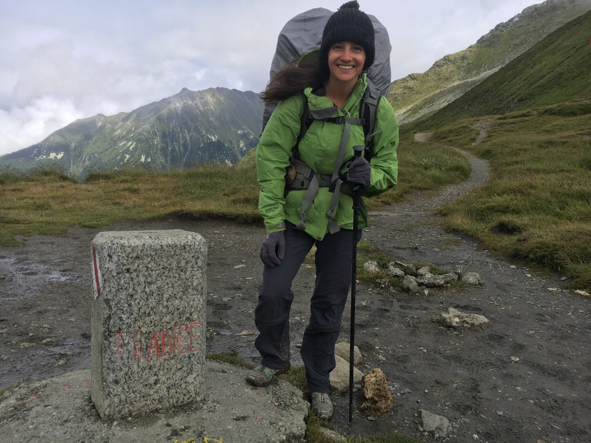
Pass 1: The French-Swiss Border at Col de Balme! One down, 10 to go!
We headed up over the Col de Balme, the first of eleven passes we would cross on the trek. This pass was particularly notable, however, because it takes you over the border between France and Switzerland. One pass down, ten to go. We descended the knee-pounding slope, past weary TMB hikers who were near the end of their trip. Two hours later, we found ourselves in the small, cheap (SFr 8) campground in Le Peuty, which thankfully had a shelter where we cooked and dried out for a few hours. The hiking was hard and everything was wet, but we were hopeful that a change in the weather could turn things around.

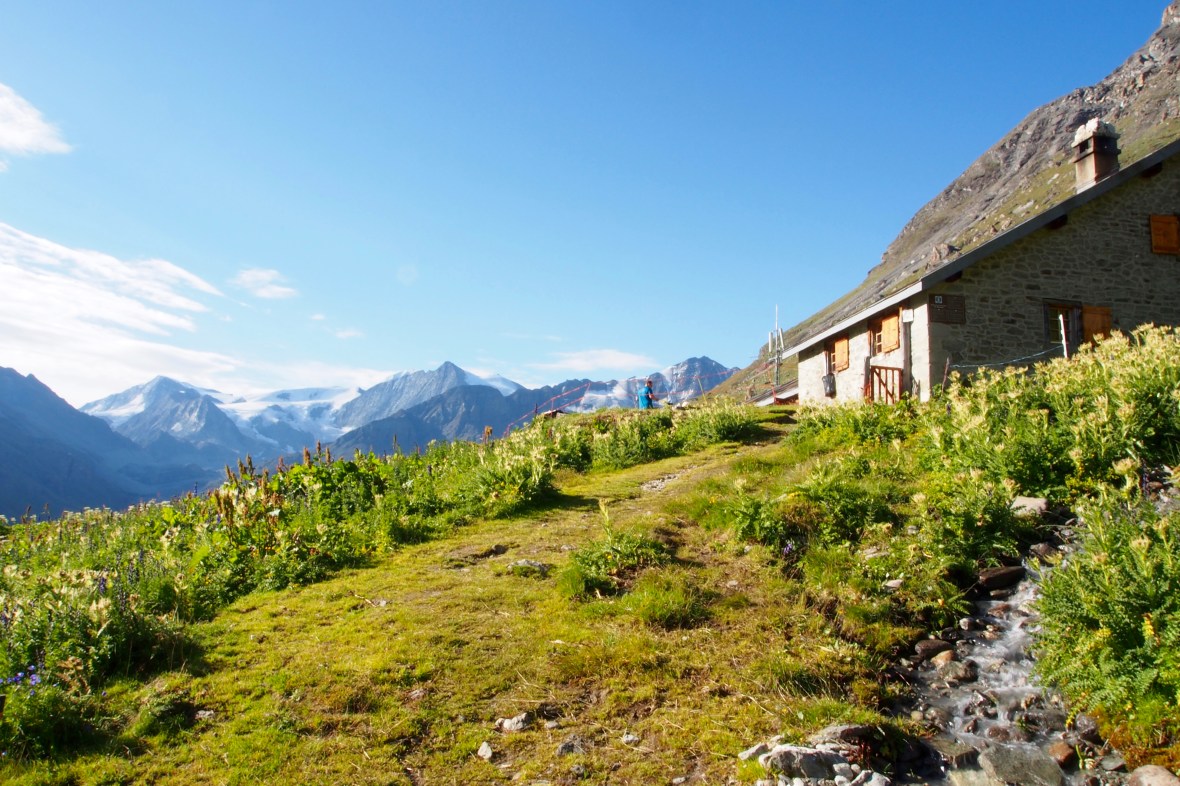
Quintessential Swiss mountain scene from day three – peaks, glaciers, wildflowers, streams… doesn’t get old.
Day Three – Le Peuty to Champex Lac (14 km, 1386m gain, 1199m loss): The day dawned a bit more clearly, encouraging us to take the standard Fenetre de l’Arpette route, rather than the longer but easier “Bovine route.” Tortured is the appropriate adjective Kev Reynolds uses to describe the Glacier du Trient, and the trail offers up close views of the broken, mangled ice. You can almost see the glacier shrinking with each passing moment. As we descended, we were lucky to see a pair of Ibex. The big, elusive, long horned animals were elegantly prancing around the awkward boulders that gave us and the other hikers trouble. We settled a few hours later at the overpriced (SFr 30 per night) campground in Champex Lac, a quaint Swiss village on a small lake. Maybe it’s because they live in such a beautiful place, but the residents we encountered there were particularly friendly. The cheese monger patiently sliced and described each regional cheese to help us settle on a mild Verbier specialty, and the baker at local bakery threw in free croissants with our loaf of bread. No one said “Welcome to Switzerland,” but after a tough day on the trail, we sure felt welcomed. Things were looking up!

Pass 2: Fenetre de l’Arpette. The views were amazing?
Day Four – Champex Lac to Le Chable (13 km, 104m gain, 749m loss): Described in the book as an easy, mostly downhill day, we underestimated the challenge ahead. Stocked up with food for a few days, our packs were heavy, and along with the descent out of Champex Lac, our knees and backs were aching by midday. The surprising heat in Le Chable (85 F/30 C) and the lack of shade left us with little to desire to linger, plus there was no campground in sight, only expensive hotels, so we decided to get a head start on the following day’s uphill hike by continuing past Le Chable to look for a “wild camping” spot. After passing through a series of adorable Swiss hamlets, we found a discreet place to lay our tent about 90 minutes above town, just outside Les Verneys, which had a water source and a public bathroom. Our efforts were rewarded all evening as we dined and drank, views of the valley highlighted below us in the waning light.

Wining and dining from our perch above Les Verneys! Such a treat.
Day Five – Le Chable to Cabane du Mont Fort (9km, 1636 gain): Even though our day technically began past Le Chable in Les Verneys, the day was essentially one long, steep uphill climb. First through forest, past idilic old ski cabins, then up and up until we reached the main ski areas of Verbier. Just after noon, the Cabane came into sight, perched on a rocky outcropping in the middle of the a giant cirque. It was Connor’s birthday, so we decided to splurge on one night of traditional European hut-style lodging. We happily dropped our bags in our (tiny) private room and spent the afternoon basking in the sun on the deck of the Cabane. An eclectic group of hikers assembled that evening, and we became fast friends over beers while we lounged and took in sunset views of the Mont Blanc massif. Another perk of the hut upgrade – a three course dinner! Although we were so hungry you could have fed us anything, the salad, spaghetti, and ice cream hit the spot.


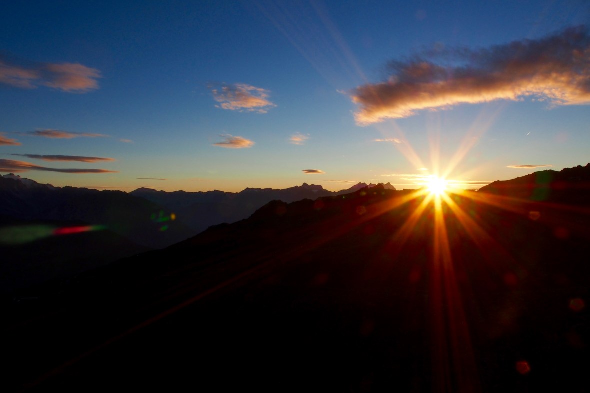
Sunset from Cabane du Mont Fort
Day Six – Cabane du Mont Fort to Refuge la Barma (16 km, 985 gain, 840m loss): We were the first to rise in the 60 person cabin, anticipating a scenic and very long day ahead. There’s no better time to hike than early in the morning, the day slowly dawning, the air cool and crisp, and as we left the Cabane, the trail immediately opened up to an impressive stretch of hiking. Within an hour, we were debating whether or not it was the best section of trail we’ve ever walked. As we crossed the famous Bec de Roses mountain face, the Combin Massif captured the view in front of us, with it’s massive Corbassiere Glacier tumbling down from the summit. Across the valley stood Mont Blanc, the jagged massif with over a dozen of sharp peaks above 4,000 meters.
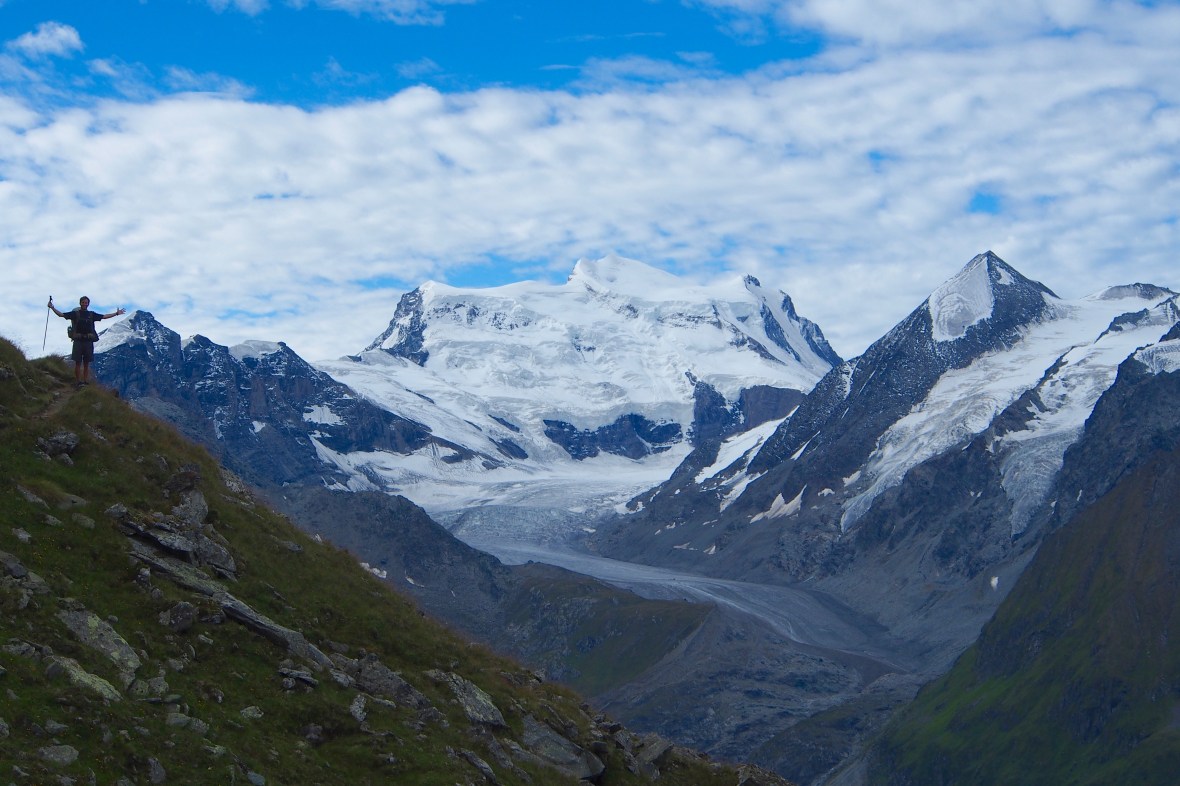
Connor and the Combin Massif


Our feet tread on soft dirt, but our legs pushed through tall grass and colorful wildflowers, the perfect habitat for an uncountable number of bugs and butterflies, which darted to and fro, their excitement seeming to match ours. Since we were the first trekkers to hit the trail that morning, the animals that normally spend the day hiding were still wandering near the trails, and we stopped several times to watch herds of chamois bouncing easily around the cliffy mountain edges. This moment, we both reflected, is why we started walking nearly a week earlier, through the rain with heavy packs. Moments like these make all the hard moments worthwhile.


We’re repeatedly impressed by our surroundings as we cover mile after mile: high, exposed trails, wildflower meadows, crystal clear lakes, and more (tragically receding) glaciers. We crossed a total of four mountain passes on this long alpine day, in addition to one icy barefoot creek crossing, which made for well over 8 hours of hiking.


Our shaky legs were happy when we found the Refuge la Barma, a small outpost previously used as a cow shed and dairy farm, where for SFr 13 you can bunk up and enjoy a roof, cooking area and SFr 3 beers. We had lucked out with good weather all day, but we saw thunderclouds approaching, and after our toughest, and most satisfying day on the trail yet, we were happy to splurge on a night in the refuge. Our decision was quickly validated as rain started to pour down, and we spent the rest of the evening happily sheltered, enjoying a few beers, a hot meal, and the company of new friends as we regaled one another with stories from our long, incredible day.
Refuge la Barma
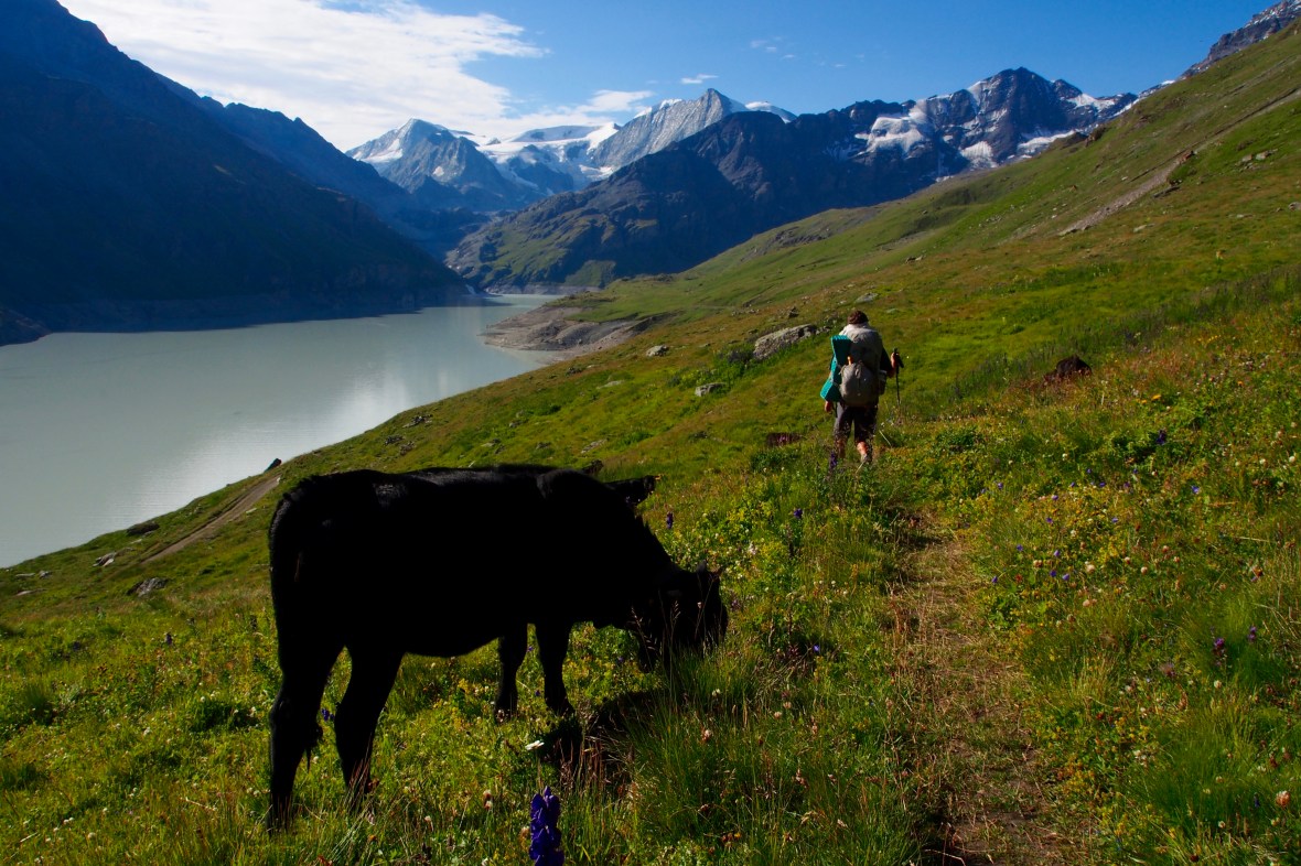
Day Seven – Refuge la Barma to Arolla (14km, 635m gain, 1253m loss): We left the refuge and spent a leisurely, sunny morning walking the length of the Lac de Dix, alongside herds of cattle, a nice way to wake up our stiff joints. At the end of the lake, the trail breaks away, heading up toward the glacier moraine, evidence of a once great glacier in this valley. Like most of the glaciers we’ve passed, this one is nearly gone, hanging from the peak above like a singular diamond on a necklace, the bergschrund large enough to swallow any of the villages we’ve walked through.
Lac de Dix trail. The Pas de Chevres is the leftmost saddle of the mountains.
After some sketchy boulder hopping, we reached the final steep face to the Pas de Chevres, where the Swiss have kindly bolted a series of three iron ladders, nearly vertical, to aid climbers in reaching the top. What a thrill – climbing steep ladders, up and over a rocky ridge, huge peaks and big views all around, the glacial moraine far below. Once over, we made our way down the long hill to the village of Arolla where we found a small grocery store, just large enough to have the supplies we need for the night: meat, cheese, baguette, wine, chocolate. It’s become our standard order by this point – delicious and affordable.

The ladders of Pas de Chevres – super fun!
Even though it rained for at least an hour every day of the trip thus far, the amazing views kept smiles on our faces, and overall, we were feeling good. Tired and a bit sore, but good. To see an overview of the entire Haute Route and our packing list, see our previous post. To read about our final week on the Haute Route, stay tuned for our next post! And as always, if you have any comments or questions, we’d be happy to share more about our journey with you – comment on the post or send us a message on Instagram @theadventuregoeson!

What an adventure you two are having, great to follow and so very well done. I am super curious – what is your favourite trip so far and why? I am sure that is a hard question to answer but hopefully something stands out:)
Hi Sharon! Great question and there’s no easy answer. Nepal was the most serene, breathtaking, spiritual place of the year. Vietnam was beautiful and the food was great. France/Spain/Italy all lived up to expectations, we’ve absolutely loved our time here. The list goes on.. we haven’t decided which one is the best yet!
I am so impressed with your adventure , the pics, the narrative. Words fail me. 💋💋