Why the Haute Route? A short bus ride from Geneva and boom – we were in the French Alps! Legendary Chamonix is a destination in its own right and also happens to be the starting point for the Haute Route and the Tour de Mont Blanc (TMB). We considered doing both of these famous treks and this helpful comparison tipped us in favor of the longer, harder, more scenic Haute Route. You get to see more of the Alps on the Haute Route, including Mont Blanc and the Matterhorn, and the idea of hiking into the quintessential Swiss mountain town of Zermatt was incredibly appealing. However, since you are hiking from France to Switzerland, this route requires some logistical planning if you need to leave behind some of your gear (as we did).

Views of the Matterhorn (left) tipped us in favor of the Haute Route rather than the more popular Tour de Mont Blanc (TMB)
History of the Route: The “Walker’s Haute Route” is a slightly lower route than the 150 year old, classic mountaineer’s Haute Route. The mountaineer’s Haute Route is typically done as a ski traverse and requires mountaineering gear for glacier travel. The Walker’s Haute Route requires no technical climbing skills or gear. The route winds under 10 of the 12 highest summits in the Alps, crosses 11 mountain passes, and takes you from French mountain villages to the German-speaking town of Zermatt.

Saint Bernard guiding a final stretch of the trek on the Europaweg
Quick facts about the Walker’s Haute Route:
- Distance: 116 miles (187 km)
- Starting point: Chamonix, France
- Ending point: Zermatt, Switzerland
- Time: 12 – 15 days
- Total elevation gain: 39,360 ft (12,000 m)
- Total elevation loss: 32,800 ft (10,000 m)
- Highest point on the route: 9,799 ft (2,987 m)
- Budget: $25/person/day if camping & cooking your own food, $100/person/day if staying in the huts & buying meals
- Average day: 7-12 km over 5-7 hours, with 1,500 m in elevation gain and loss
Getting to Chamonix: Fly into Geneva, Switzerland and catch one of the many daily busses to Chamonix for about $20. It is also possible to take trains and busses from other nearby European cities.


Returning to Chamonix from Zermatt: If you need to return to Chamonix (maybe you stashed gear), it’s easy to catch a train for about $150 or as we did, hitchhike. We got 5 rides over 6 hours, easily getting back to Chamonix in time for dinner.

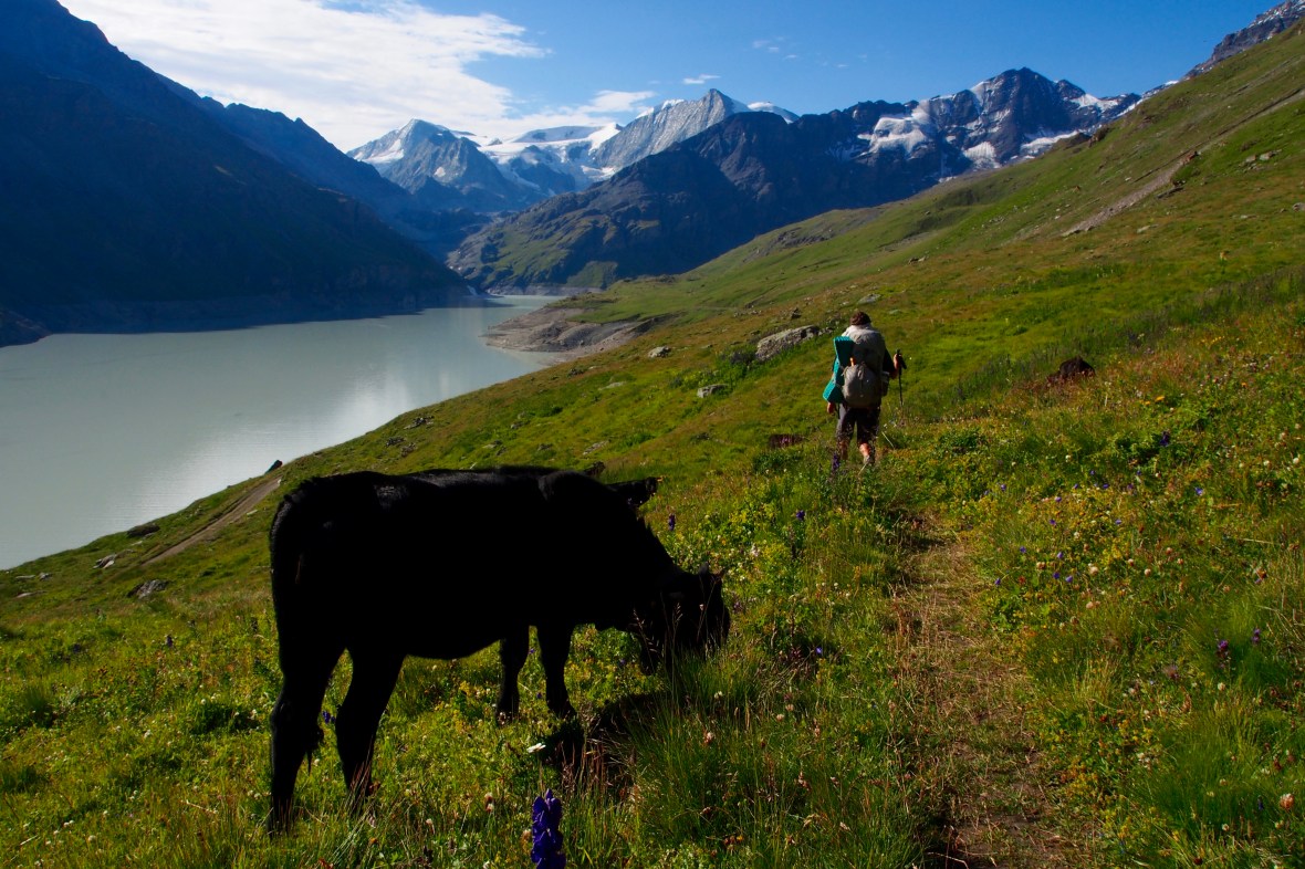
Most days on the Haute Route involve the steep ascent of a mountain pass, followed by a descent into a valley like this one
Camping: We camped 11 of the 13 nights, and many people complete the route camping every night. There were official campgrounds in: Chamonix, Argentiere, Le Peuty, Champex Lac, Arolla, Zinal, Randa, and Zermatt. You can find more if you’re willing to venture slightly off route. The cost and quality of amenities in the campgrounds varies widely ($8-$30/night). You can also camp in the backcountry, although this is officially discouraged. If you choose to “wild camp” as they call it in Europe (AKA backcountry camping), you are encouraged to be discrete, setting up camp after dark and taking it down before sunrise, leaving no trace.

Camping made the trek more affordable and gave us the freedom to go at our own pace. Not to mention the perk of waking up to views like this.
Lodging: Most walkers choose to complete the route by staying in mountain huts each night. Again, the quality and price of these accommodations varies widely. The huts are not cheap ($40-$70/person per night, even more if meals are included), and it is often recommended to make reservations in advance. Most huts offer breakfast, lunch, and dinner options, but some only have “self-service” kitchens (i.e., bring and cook your own food). Most but not all huts will also have showers available, with prices ranging from free to $5.


Drinking Water: According to our research and most people we talked to, there is no need to purify water in the Alps. There are almost always water fountains in the villages and hamlets that have clean drinking water, and the water at the mountain huts and campgrounds is generally safe for drinking. Many people will also drink directly from mountain streams, so long as you are above the elevation of livestock. We did carry our water filter, but did not purify water at any time on the trek. It might be wise to bring a form of water purification just in case, depending on your tolerance for risk.

The streams flowing at higher altitudes on the Haute Route likely contain some of the purest glacial water you can find
Weather: We frequently checked this website for up to date forecasts, but be prepared for rain, snow, wind, hot sun, and weather that changes quickly. We didn’t encounter snow on our trek, but there were days of heavy, cold rain and also hot, dry sun. The week following our trek, there was snow at several of the mountain huts (in mid August), so the risk of snow and cold temperatures is real.
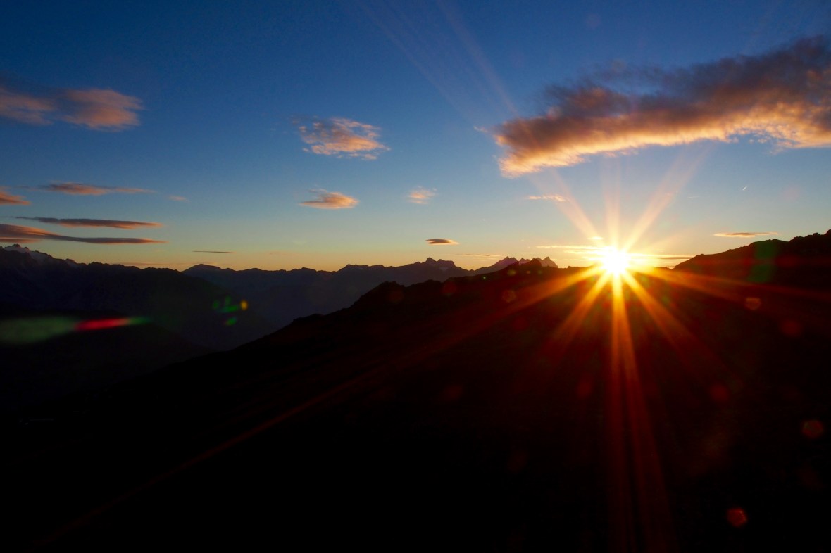
There was no shortage of incredible mountain sunsets to behold on the Haute Route
Season: July – September. Snow covers much of the route until mid or end of July. The earlier you can go, the less crowded it will be, but the snow can be a major hinderance to crossing a mountain pass. While trekking in October may be possible, the likelihood of snow increases significantly.
We lucked out with quite a few warm and sunny days, although there were an equal number of days that were cold and rainy…
Maps: Because you cross several regions on the trek, multiple maps are needed, and they aren’t cheap. We decided to purchase the kindle version of Kev Reynolds’ Trekking Chamonix to Zermatt: The Classic Walker’s Haute Route guidebook instead, which has helpful descriptions and crude maps. You can also download offline maps on your phone, with apps like Google Maps and Maps.Me. Attempting such a trek without a map is not necessarily recommended, but the trails of the Swiss Alps may be the most well marked trails in the world, and the guidebook was totally sufficient for us.

Yellow trail signs like these are found at almost all trail junctions, whether it’s at the top of a high mountain pass or among the streets of a cozy village. Thank you Switzerland!
Fitness: This trek is strenuous. You hike for an average of 5 – 7 hours each day, covering an average of 7-12 km/day, sometimes up to 20km. You cross a large mountain pass on most days, gaining and losing an average of 1,500m each day. We found the Walker’s Haute Route to be more difficult than both the Annapurna Circuit and the Three Passes Trek in Nepal. Granted, we were carrying our camping gear and cooking supplies, so we had 10 – 15 pounds more than most hikers, but the hike is difficult by any standard.

No technical skills are required on the Walker’s Haute Route, but there is an opportunity to climb a series of fun, nearly vertical ladders to cross the Pas de Chèvres
Permits? No permit is required for the Walker’s Haute Route.

One of many tragically receding glaciers that you get to see on the Haute Route
The Walker’s Haute Route Packing List: Here is a list of everything we brought on the trek (per person);
- Down sleeping bag (1)
- Sleeping Pad (1)
- Big Agnes UL 3 season tent
- Cocoon sleeping bag liner (1)
- Light down jacket (1)
- Gortex rain shell jacket (1)
- Waterproof backpack cover (1)
- Beanie (1)
- Buff/bandana (1) – keep dust out of your mouth, sun off your neck, and more
- Lightweight hiking pants (1) – you do not need soft shell or heavy hiking pants
- Shorts (at least one pair for trekking – a pair of convertible pants would suffice – maybe a second pair for sleeping/chillin)
- Short sleeve hiking t-shirt (2)
- Long sleeve hiking shirt (1)
- Base layer bottoms for sleeping and layering warmth (1)
- Base layer top for layering warmth (1)
- ~5 pair socks
- ~2-5 pair underwear
- Sunglasses
- Hiking boots or running shoes
- Sandals
- Shampoo, lotion, chapstick, toothpaste/brush, toilet paper, hand sanitizer, soap, baby powder, baby wipes
- Sunscreen
- Food: snacks + two days worth of food if you’re making your own meals
- Stove, lighter, and fuel (we used an MSR stove and carried 2-3 fuel canisters)
- Water bottle
- Travel towel
- Trekking poles
- Emergency kit: ibuprofen and opiate painkillers, cortisone cream, antibiotic ointment, prescription antibiotics, antiparasitics, bandages/medical tape, treatment for any other conditions to which you may be prone
- Duct tape and zip ties for repairs
- MSR Autoflow Gravity water filter
- Map/guidebook
- Headlamp with charger and/or extra batteries
- Deck of cards
- Earplugs
- iPhone and charger
- Journal & pen
- Olympus OM-D E-M5 Camera with extra battery and battery charger
- Kindle with charger

Mountain wizards
Stay tuned for more detailed posts about the route! Questions or comments? Comment on the blog or send us a message @theadventuregoeson on Instagram!

Show offs! My goodness, you two are having an unbelievable adventure. I’m sure all you family and friends are jealous, envious and awed by your fortune. much love, pops
On Thu, Aug 24, 2017 at 9:10 AM, The Adventure Goes On wrote:
> The Adventure Goes On posted: “Why the Haute Route? A short bus ride from > Geneva and boom – we were in the French Alps! Legendary Chamonix is a > destination in its own right and also happens to be the starting point for > the Haute Route and the Tour de Mont Blanc (TMB). We considered doi” >
Love these, and you guys! Am sharing site with Mimi, Booth and Butt, and Marie!
Love from Maine
We love you too! Say hi to everyone in Maine for us and give Mimi and big hug!